I want to plot some spatial data using the leaflet package in R, however the generated raster image seems to be shifted compared to a reference grid. I suspect map projection issue, but I am not expert on the topic, so any help would be appreciated.
Here is a minimal code to plot the map:
library(leaflet)
library(sp)
library(raster)

set.seed(111)

# create dummy data -rectangular grid with random values
m = 10
n = 10
x = seq(45,48,length.out = m)
y = seq(15,18,length.out = n)
X = matrix(rep(x, each = n), nrow = n)
Y = matrix(rep(y, m), nrow = n)

# collector dataframe
points = data.frame(value = rnorm(n*m), lng = c(Y), lat = c(X))

## create raster grid
s = SpatialPixelsDataFrame(points[,c('lng', 'lat')], data = points)
# set WGS84 projection
crs(s) = sp::CRS("+proj=longlat +ellps=WGS84 +datum=WGS84 +no_defs")

r = raster(s)

# add coloring
pal = colorNumeric(c("#0C2C84", "#f7f7f7", "#F98009"), points$value,
                    na.color = "transparent")

## plot map
leaflet() %>% addProviderTiles("CartoDB.Positron") %>%
   addRasterImage(r, colors = pal, opacity = 0.6)
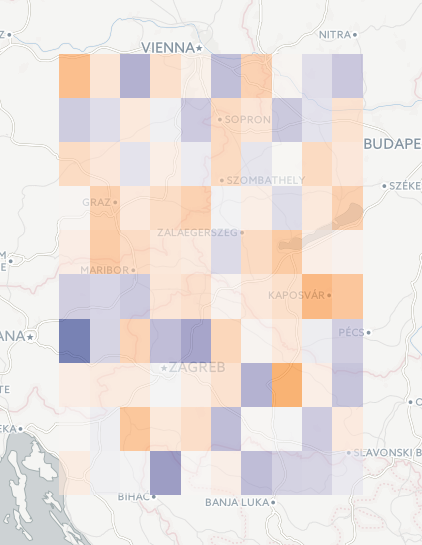
This produces this map, which is ok at first sight:

If a grid is added to this map:
## grid
dx = diff(x)[1]/2
dy = diff(y)[1]/2

rect_lng = sapply(points$lng, function(t) c(t-dx, t+dx))
rect_lat = sapply(points$lat, function(t) c(t-dy, t+dy))

leaflet() %>% addProviderTiles("CartoDB.Positron") %>%
  addRectangles(
    lng1=rect_lng[1,], lat1=rect_lat[1,],
    lng2=rect_lng[2,], lat2=rect_lat[2,],
    fillColor = "transparent",
    weight = 1
  ) %>%
  addRasterImage(r, colors = pal, opacity = 0.6)
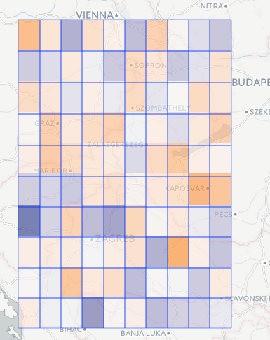
The map looks like this:
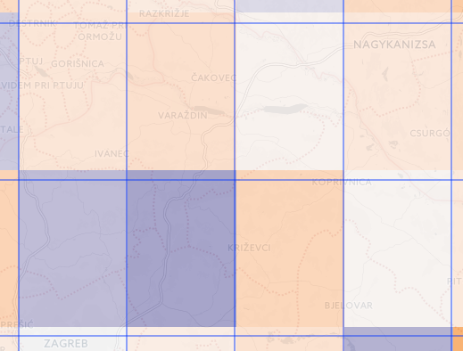
Here we can see that the grids are not matching.

What is the reason of this mismatch? How could it be eliminated? I tried various projections in vain. The only thing that worked was to use addRectangle instead of addRasterImage, however that requires much more computation and slows down the process, thus I want to avoid. Note that in the above example addRectangle is used only for having a reference, in the final code I do not want to use it.
For maps with more cells(grids) the mismatch is quite large, can be larger than the size of a single cell.
Thanks in advance for any help.
EDIT
The problem might be related to the projection issue between ellipsoid and sphere projections, see the last question here:
to convert between WGS84 and mercator on the sphere there will be substantial shifts in the Y mercator coordinates. This is because internally cs2cs is having to adjust the lat/long coordinates from being on the sphere to being on the WGS84 datum which has a quite differently shaped ellipsoid.
However, I was not able to solve the problem with the recommended 'trick': +nadgrids=@null.


leaflet::projectRasterForLeaflet) creates an output raster with the same pixel/cell dimensions as the input raster (in this case, 10x10), whereas normally you want to project using the output dimensions you are actually rendering to. But in this case there aren't really fixed output dimensions, since the user can zoom in and out. I'm making a small projected raster and then scaling it up linearly to match the zoom, and that's likely what's introducing the drift. – Archipelago