Plot strings of text on Basemap in place of points in Python
Asked Answered
S

1

5

I have 79 lat and lons that I have data for to plot on a Basemap in Python. I have an array of 79 numbers to go along with it that I would like to plot instead of a normal dot (i.e. I would like a "1" or a "2" to show up instead of a usual dot). I tried the plt.annotate function, but that didn't work.

import numpy as np
import matplotlib.pyplot as plt
from mpl_toolkits.basemap import Basemap

locs = np.genfromtxt('/Volumes/NO_NAME/Classwork/OK_vic_grid.txt')
lat = locs[:,1] # 79 values
lon = locs[:,2] # 79 values

m = Basemap(projection='stere',lon_0=-95,lat_0=35.,lat_ts=40,\
        llcrnrlat=33,urcrnrlat=38,\
        llcrnrlon=-103.8,urcrnrlon=-94) 

X,Y = m(lon,lat)    
m.drawcoastlines()
m.drawstates()
m.drawcountries()
m.drawmapboundary(fill_color='lightblue')
m.drawparallels(np.arange(0.,40.,2.),color='gray',dashes=[1,3],labels=[1,0,0,0])
m.drawmeridians(np.arange(0.,360.,2.),color='gray',dashes=[1,3],labels=[0,0,0,1])

m.scatter(X,Y)
????? (Want to plot an array "maxpc" which has 79 numbers that I want to plot the string of)

OK_vic_grid.txt:

1   33.75   -97.75
2   33.75   -97.25
3   33.75   -96.75
4   33.75   -96.25
5   33.75   -95.75
6   33.75   -95.25
7   33.75   -94.75
8   34.25   -99.75
9   34.25   -99.25
10  34.25   -98.75
11  34.25   -98.25
12  34.25   -97.75
13  34.25   -97.25
14  34.25   -96.75
15  34.25   -96.25
16  34.25   -95.75
17  34.25   -95.25
18  34.25   -94.75
19  34.75   -99.75
20  34.75   -99.25
21  34.75   -98.75
22  34.75   -98.25
23  34.75   -97.75
24  34.75   -97.25
25  34.75   -96.75
26  34.75   -96.25
27  34.75   -95.75
28  34.75   -95.25
29  34.75   -94.75
30  35.25   -99.75
31  35.25   -99.25
32  35.25   -98.75
33  35.25   -98.25
34  35.25   -97.75
35  35.25   -97.25
36  35.25   -96.75
37  35.25   -96.25
38  35.25   -95.75
39  35.25   -95.25
40  35.25   -94.75
41  35.75   -99.75
42  35.75   -99.25
43  35.75   -98.75
44  35.75   -98.25
45  35.75   -97.75
46  35.75   -97.25
47  35.75   -96.75
48  35.75   -96.25
49  35.75   -95.75
50  35.75   -95.25
51  35.75   -94.75
52  36.25   -99.75
53  36.25   -99.25
54  36.25   -98.75
55  36.25   -98.25
56  36.25   -97.75
57  36.25   -97.25
58  36.25   -96.75
59  36.25   -96.25
60  36.25   -95.75
61  36.25   -95.25
62  36.25   -94.75
63  36.75   -102.75
64  36.75   -102.25
65  36.75   -101.75
66  36.75   -101.25
67  36.75   -100.75
68  36.75   -100.25
69  36.75   -99.75
70  36.75   -99.25
71  36.75   -98.75
72  36.75   -98.25
73  36.75   -97.75
74  36.75   -97.25
75  36.75   -96.75
76  36.75   -96.25
77  36.75   -95.75
78  36.75   -95.25
79  36.75   -94.75
Standard answered 22/9, 2015 at 1:59 Comment(7)
What is your question exactly? A little more background might help get to an answer.Pergolesi
@skywalker I would like a scatter plot on my Basemap, but instead of dots at each lat-lon location, I want to have the numbers that I have contained in "maxpc" show up.Standard
Could you gist OK_vic_grid.txt?Pergolesi
Why not a heat map? You literally want to see the numeric value at each longitude and latitude? Just curious.Pergolesi
@skywalker I'm not familiar with a heat map. But yeah, I just want numbers that I have in the maxpc array at each of those lat and lons instead of dots.Standard
Let us continue this discussion in chat.Pergolesi
One final reference search "sea-level pressure weather map" here: matplotlib.org/basemap/users/examples.htmlPergolesi
A
8

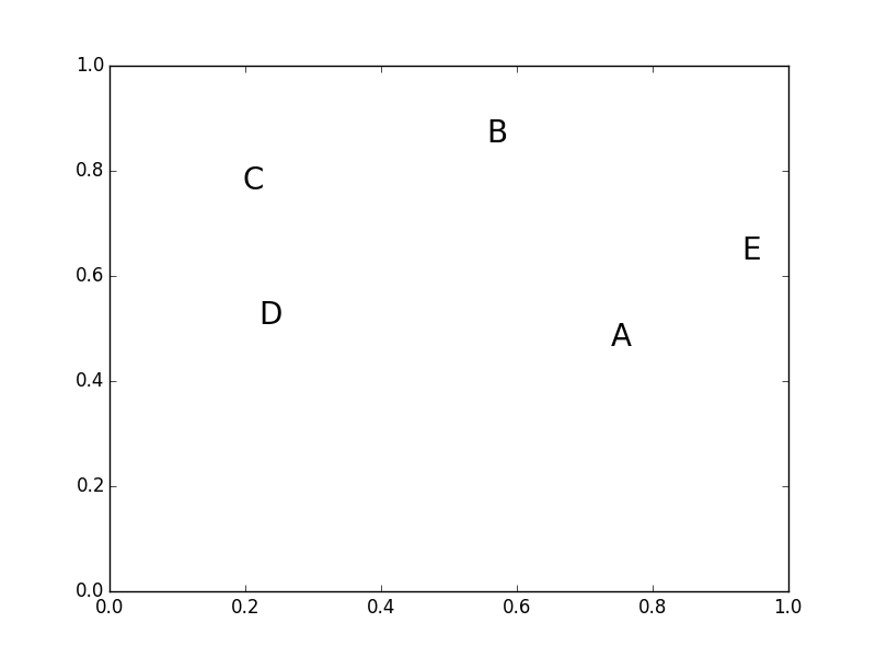
ax.scatter and ax.text both expect a single x, y point, rather than an array of locations.

Either will work perfectly fine, but you'll need to use a loop.

For example:

import numpy as np
import matplotlib.pyplot as plt

xy = np.random.random((5, 2))
text = ['A', 'B', 'C', 'D', 'E']

fig, ax = plt.subplots()
for (x,y), label in zip(xy, text):
    ax.text(x, y, label, ha='center', size=20)
plt.show()

enter image description here

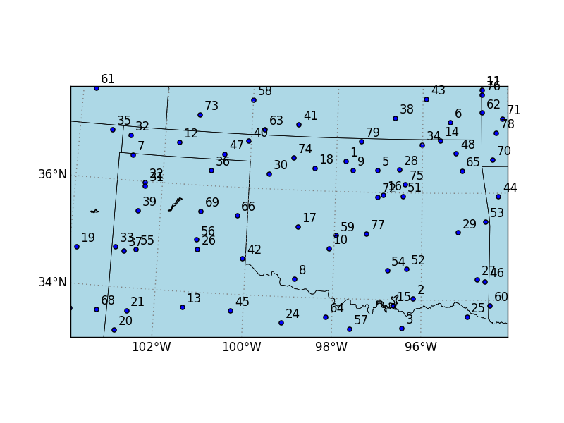
With basemap, you'll need project your longitudes and latitudes into projected map coordinates (i.e. your X and Y arrays). For example (I'll also use annotate here to offset the label by a few points):

import numpy as np
import matplotlib.pyplot as plt
from mpl_toolkits.basemap import Basemap

num = 79
lat = 5 * np.random.random(num) + 33
lon = 10 * np.random.random(num) - 104

fig, ax = plt.subplots()
m = Basemap(projection='stere',lon_0=-95,lat_0=35.,lat_ts=40,
            llcrnrlat=33,urcrnrlat=38,
            llcrnrlon=-103.8,urcrnrlon=-94,
            resolution='h', ax=ax)

X,Y = m(lon,lat)
m.drawcoastlines()
m.drawstates()
m.drawcountries()
m.drawmapboundary(fill_color='lightblue')
m.drawparallels(np.arange(0.,40.,2.),color='gray',dashes=[1,3],labels=[1,0,0,0])
m.drawmeridians(np.arange(0.,360.,2.),color='gray',dashes=[1,3],labels=[0,0,0,1])

ax.scatter(X,Y)

for i, (x, y) in enumerate(zip(X, Y), start=1):
    ax.annotate(str(i), (x,y), xytext=(5, 5), textcoords='offset points')

plt.show()

enter image description here

On a side note, you might also consider using cartopy instead of basemap. basemap has been more or less completely superseded by cartopy. Both are matplotlib-based mapping toolkits, cartopy is just a lot nicer, i.m.o.. The map axes are true subclasses of Axes, so there's no separate Basemap object, it's a true Axes, instead. Furthermore, Cartopy has a few more features than basemap, and is typically faster, in my experience.

Across answered 22/9, 2015 at 2:26 Comment(7)
Thanks for the response, Joe. I get an error message that says Basemap doesn't have annotate as an attribute when I run this.Standard
@Standard - You'll need to use ax.annotate, instead of m.annotate. (I had a typo in the initial version. Editing now.)Across
Ahh, perfect! Thank you.Standard
Joe, cartopy looks great. I have a free student copy of Canopy and it seems like I have to pay for it, though.Standard
You can install it separately, regardless. I don't know what versions of Canopy provide it by default, but none of them should prevent you from installing it. (Incidentally, while Canopy is quite nice, you might have a look at Anaconda, as well, for a similar distribution under a more permissive license.)Across
Great. Thanks for the info!Standard
is there any way to avoid the foor loop to print the text is I am using for example Pandas?Cyanotype

© 2022 - 2024 — McMap. All rights reserved.