You could use OSMnx.
Here is a sample code that do what you're asking for:
import osmnx as ox
import networkx as nx
from datetime import timedelta


# The place where your 2 points are located. It will be used to create a graph from the OSM data
# In this example, the 2 points are two addresses in Manhattan, so we choose "Manhattan"
# It could be a bounding box too, or an area around a point
graph_area = ("Manhattan, New York, USA")

# Create the graph of the area from OSM data. It will download the data and create the graph
G = ox.graph_from_place(graph_area, network_type='drive')
# (For a better accuracy, create a graph with lot more nodes:)
#G = ox.graph_from_place(graph_area, network_type='drive', simplify=False)

# OSM data are sometime incomplete so we use the speed module of osmnx to add missing edge speeds and travel times
G = ox.add_edge_speeds(G)
G = ox.add_edge_travel_times(G)

# Save graph to disk if you want to reuse it
ox.save_graphml(G, "Manhattan.graphml")

# Load the graph
#G = ox.load_graphml("Manhattan.graphml")

# Plot the graph
fig, ax = ox.plot_graph(G, figsize=(10, 10), node_size=0, edge_color='y', edge_linewidth=0.2)

# Two pairs of (lat,lng) coordinates
origin_coordinates = (40.70195053163349, -74.01123198479581)
destination_coordinates = (40.87148739347057, -73.91517498611597)

# If you want to take an address (osmx will use Nominatim service for this)
# origin_coordinates = ox.geocode("2 Broad St, New York, NY 10005")

# In the graph, get the nodes closest to the points
origin_node = ox.nearest_nodes(G, Y=origin_coordinates[0], X=origin_coordinates[1])
destination_node = ox.nearest_nodes(G, Y=destination_coordinates[0], X=destination_coordinates[1])


# Get the shortest route by distance
shortest_route_by_distance = ox.shortest_path(G, origin_node, destination_node, weight='length')

# Plot the shortest route by distance
fig, ax = ox.plot_graph_route(G, shortest_route_by_distance, route_color='y', route_linewidth=6, node_size=0)

# Get the shortest route by travel time
shortest_route_by_travel_time = ox.shortest_path(G, origin_node, destination_node, weight='travel_time')

# Plot the shortest route by travel time
fig, ax = ox.plot_graph_route(G, shortest_route_by_travel_time, route_color='y', route_linewidth=6, node_size=0)

# Plot the 2 routes
fig, ax = ox.plot_graph_routes(G, routes=[shortest_route_by_distance, shortest_route_by_travel_time], route_colors=['r', 'y'], route_linewidth=6, node_size=0)

# Get the travel time, in seconds
# Note here that we use "nx" (networkx), not "ox" (osmnx)
travel_time_in_seconds = nx.shortest_path_length(G, origin_node, destination_node, weight='travel_time')
print("travel time in seconds", travel_time_in_seconds)

#The travel time in "HOURS:MINUTES:SECONDS" format
travel_time_in_hours_minutes_seconds = str(timedelta(seconds=travel_time_in_seconds))
print("travel time in hours minutes seconds", travel_time_in_hours_minutes_seconds)

# Get the distance in meters
distance_in_meters = nx.shortest_path_length(G, origin_node, destination_node, weight='length')
print("distance in meters", distance_in_meters)
# Distance in kilometers
distance_in_kilometers = distance_in_meters / 1000
print("distance in kilometers", distance_in_kilometers)
And by the way thanks to Geoff Boeing for this great library!
Update 2023 relative to @KBurchfiel comment:
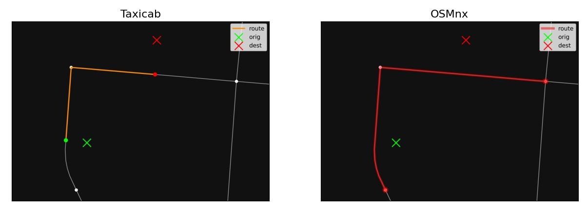
In fact, it will depend on the shape of the path. Sometimes it will be more accurate, but sometimes it will be even more inaccurate.
Look at these images (they are from https://github.com/nathanrooy/taxicab):
![enter image description here]()
![enter image description here]()
![enter image description here]()
You can do 2 things to produce a more accurate distance measurement:
- Add
simplify=False when creating the graph: G = ox.graph_from_place(graph_area, network_type='drive', simplify=False). Your graph will have lot more nodes.
- Use Taxicab from nathanrooy
Here is an example using Taxicab:
import osmnx as ox
import networkx as nx
import taxicab as tc

# Load the graph
G = ox.load_graphml("Manhattan.graphml")
origin_coordinates = (40.70195053163349, -74.01123198479581)
destination_coordinates = (40.87148739347057, -73.91517498611597)
route = tc.distance.shortest_path(G, origin_coordinates, destination_coordinates)
tc.plot.plot_graph_route(G, route)
Note that Taxicab has this function for distances only, not for travel times. I have no time at the moment to code it, but if you or another reader have it, feel free to add it here and/or to contribute to Taxicab/Osmnx ;-)


