A few thougths on your question:
I need to convert in to linestring using this function ST_MakeLine and
then store, right?
Yes, to merge multiple points into a LINESTRING you can use ST_MakeLine:
SELECT ST_AsText(
       ST_MakeLine(ARRAY[ST_MakePoint(-122.21,37.77),
                         ST_MakePoint(-157.82,21.29),
                         ST_MakePoint(178.43,-18.14),
                         ST_MakePoint(153.02,-27.46)]));

                              st_astext
---------------------------------------------------------------------
 LINESTRING(-122.21 37.77,-157.82 21.29,178.43 -18.14,153.02 -27.46)
(1 Zeile)
How to query that based on my requirement as I have mentioned above
Create a buffer on each point of your LINESTRING and check wether other geometries are inside of it.
First, you have to split your rout LINESTRING into POINTs using ST_DumpPoints ...
db=# SELECT ST_AsText((ST_DumpPoints('LINESTRING(-122.21 37.77,-157.82 21.29,178.43 -18.14,153.02 -27.46)'::GEOMETRY)).geom);
      st_astext
----------------------
 POINT(-122.21 37.77)
 POINT(-157.82 21.29)
 POINT(178.43 -18.14)
 POINT(153.02 -27.46)
(4 Zeilen)
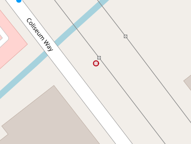
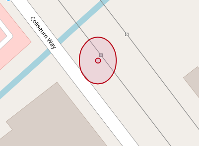
.. and then use ST_Buffer to create a buffer around each point. ST_Buffer returns a geometry with the area surrounding your point (or any other geometry type). For instance, taking the first point of your route (if I didn't switch x and y, it's somewhere in San Francisco) POINT(-122.21 37.76):
![enter image description here]()
db=# SELECT ST_AsText(
       ST_Buffer('POINT(-122.21 37.76)'::GEOMETRY,0.0001, 'quad_segs=16'));
Returns this geometry:
POLYGON((-122.2099 37.76,-122.209900481527 37.759990198286,-122.209901921472 37.7599804909678,-122.209904305966 37.7599709715323,-122.209907612047 37.7599617316568,-122.209911807874 37.7599528603263,-122.209916853039 37.7599444429767,-122.209922698955 37.7599365606716,-122.209929289322 37.7599292893219,-122.209936560672 37.7599226989547,-122.209944442977 37.7599168530388,-122.209952860326 37.7599118078736,-122.209961731657 37.7599076120467,-122.209970971532 37.7599043059664,-122.209980490968 37.759901921472,-122.209990198286 37.7599004815273,-122.21 37.7599,-122.210009801714 37.7599004815273,-122.210019509032 37.759901921472,-122.210029028468 37.7599043059664,-122.210038268343 37.7599076120467,-122.210047139674 37.7599118078736,-122.210055557023 37.7599168530388,-122.210063439328 37.7599226989547,-122.210070710678 37.7599292893219,-122.210077301045 37.7599365606716,-122.210083146961 37.7599444429767,-122.210088192126 37.7599528603263,-122.210092387953 37.7599617316568,-122.210095694034 37.7599709715323,-122.210098078528 37.7599804909678,-122.210099518473 37.759990198286,-122.2101 37.76,-122.210099518473 37.760009801714,-122.210098078528 37.7600195090322,-122.210095694034 37.7600290284677,-122.210092387953 37.7600382683432,-122.210088192126 37.7600471396737,-122.210083146961 37.7600555570233,-122.210077301045 37.7600634393284,-122.210070710678 37.7600707106781,-122.210063439328 37.7600773010453,-122.210055557023 37.7600831469612,-122.210047139674 37.7600881921264,-122.210038268343 37.7600923879533,-122.210029028468 37.7600956940336,-122.210019509032 37.760098078528,-122.210009801714 37.7600995184727,-122.21 37.7601,-122.209990198286 37.7600995184727,-122.209980490968 37.760098078528,-122.209970971532 37.7600956940336,-122.209961731657 37.7600923879533,-122.209952860326 37.7600881921264,-122.209944442977 37.7600831469612,-122.209936560672 37.7600773010453,-122.209929289322 37.7600707106781,-122.209922698955 37.7600634393284,-122.209916853039 37.7600555570233,-122.209911807874 37.7600471396737,-122.209907612047 37.7600382683432,-122.209904305966 37.7600290284677,-122.209901921472 37.7600195090322,-122.209900481527 37.760009801714,-122.2099 37.76))
![enter image description here]()
If you're wondering about the shape of this buffer, please read this answer.
And using this query you can check if another geometry is inside of this buffer (ST_Within):
db=# SELECT
       ST_Within('POINT(-122.21 37.76)'::GEOMETRY,
          ST_Buffer('POINT(-122.21 37.76)'::GEOMETRY,0.0001, 'quad_segs=16'));
 st_within
-----------
 t
(1 Zeile)
To put it all together, you can use a CTE (aka WITH clause) and write something like this:
WITH j AS (
  SELECT
    (ST_DumpPoints('LINESTRING(-122.21 37.77,-157.82 21.29,178.43 -18.14,153.02 -27.46)'::GEOMETRY)).geom AS g)
SELECT id, name, address, geom
FROM Seattle_Starbucks
WHERE ST_Within(geom,ST_Buffer(j.g,0.0001, 'quad_segs=16'))


